 |
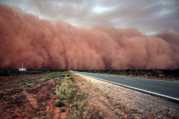
| Haboob in western Australia. This wall of dust is due to air being forced out of the coming storm ahead of the rest of the storm. Particles of all sorts fill the air while the sky appears to be filled with Nimbostratus clouds. Photo Credit: http://www.sciencemediacentre.co.nz/wp-content/upload/2009/09/red-dust.jpg
Nimbostratus clouds are low layered, usually rain filled clouds. The base height (bottom of cloud) can be as low as 2000m. The base of the cloud is where the Dew Point is located. The Dew point is where relative humidity's goal is to reach 100 percent.

Nimbostratus clouds, layered and low almost featureless rain clouds.
Photo Credit:http://www.2d-digital-art-guide.com/images/paintnimbostratusclouds4.jpg

Flat cloud base representing the Dew Point.
Valley Fog is another type of cloud that contains water located very close to the earths surface.

Valley Fog containing water droplets lays over the mountains in the Imbil State Forest in Australia.
Photo Credit: http://mw2.google.com/mw-panoramio/photos/medium/72929370.jpg
There are numerous types of storms that occur in Australia due to its varying climate and weather. Many of these are thunderstorms which produce a wide variety of lightning. Lightning is the product of positive and negative charges that are in excess, being discharged from mainly Cumulonimbus clouds. Lightning can travel in three directions such as from cloud to cloud, cloud to ground, and intracloud. The part of lightning that we are not able to see is the Stepped Leader. The Stepped Leader is the very fast lightning bolt that searches for attracting charges from another source such as the ground.

Above is an example of Zigzag lightning hitting from cloud to ground in Sydney Australia. Zigzag lightning is produced by air between the cloud and the ground that holds pockets of charge. These charges create bolts that move along the ground from pocket to pocket.
Photo Credit: http://www.lovethesepics.com/wp-content/uploads/2011/02/australia.jpg
Another form of lightning that occurs in Australia is Forked lightning. Below is an example of Forked lightning at Ayers Rock in Australia.

Forked cloud to ground lightning at Ayers Rock in Australia. Forked lightning forms when there is an overage of negative charge in the end of a bolt that can split apart in midair to form two more bolts.
Sources
|
Tuesday, April 16, 2013
Climate and Weather
The climate and weather of Australia has much variety. While most of the climate is Subtropical Desert (BWh on Koppen Scheme), it differs in come coastal areas. Due to the desert climate there have been major dust storms in western Australia. Haboobs(dust walls) signal air being forced out of a storm and hitting the ground forming the wall, behind comes a massive collaboration of dust and dirt.
Sunday, March 10, 2013
Weathering
The continent of Australia contains many sings of weathering landscapes. A main process in which weathering takes place is called jointing. Joints are cracks in rocks which split the rock to allow further weathering processes to take place.
 | |
| The picture captures numerous joints (cracks) in the rock, pointing to signs that this landscape has been physically weathered. Photo Credit: https://blogger.googleusercontent.com/img/b/R29vZ2xl/AVvXsEgFFqmqQpXhg0BRCi59wnlNYUOKIlsXtyyt5980s-FxPhjlDt6WT6HEERmtLDIml8tdqmXvxlaFtE7S38ddVG_PhriLjzj2IKm1ma8cpgyzhME0dQQkbBIkUvp6V4pH_DVjfcBYQmQnJu6U/s400/dike-Wolf-Creek-zoom.jpg
Ayers Rock (also known as Uluru) is a large sandstone rock in central Australia. The rock is known to have very little jointing. The survival of the rock is due to the lack of scree slopes and soil allowing it to stretch over 5.8 miles today. Scree (talus) is the accumulation of broken rocks or sediment around the base of a rock.

A far look at Ayers Rock, showing the lack of joints and scree.
Photo Credit: http://britishfreedom.org/wp-content/uploads/2011/11/ayers-rock.jpg
Another form of physical weathering takes place with the introduction of salt. Salt, being able to hold water, can expand and contract rocks forming splits or joints. It can also form small or large holes in the rock called alveoli (small) or tafoni (large). To the right is a picture illustrating the examples of salt weathering.

Ayers rock displays both large scale tafoni on the bottom half of the rock to the right, and small scale alveoli in the center of the picture. The white hues of the rock are signs of salt weathering creating these cavernous structures.
Photo Credit: http://www.themikezone.co
|

Tuesday, February 5, 2013
Volcanism and Faulting
The Australian Alps stretch across the southeastern border of Australia creating high plateau like mountains. The Australian Alps were formed by the splitting apart or divergent plates of a supercontinent called Gondwana (India, Australia, Antarctica, and Zealandia) 160 million years ago. Extension faults (where the earth crust of the earth pulls apart) formed between Australia and Zealandia as magma from the asthenosphere (partially molten second layer of earth) uplifted the earths crust (lithosphere or top layer) and formed new rock. The faults caused a rift valley (low and usually water filled land) to form between the continents and the Tasman sea (body of water between Australia and Zealandia) expanded in between the two continents drifting them apart. The western scarp (face of the newly faulted land mass) of the split continents left behind what was the start of the Australian Alps. Over time erosion (weathering) played the role of carving out the rest of the Australian Alps.
Sources
 |
| Photo Credit: http://www.australianalps.environment.gov.au/nature/geology.html |
 |
| Australian Alps Photo Credit: http://www.undurraarabians.com.au/home/images/stories/location/mthotham.jpg |
Australia contains many extinct volcanoes and only two remaining active volcanoes on Australian territory (Big Ben and Mawson Peak). Australia's Western Victorian Volcanic Plains are one of the most volcano dense on the continent and third largest in the world. Around 400 volcanoes exist in this region, mainly cinder cones (extrusive volcanic landforms) that have produced large basaltic (low viscosity) lava flows. Viscosity measures the thickness of a liquid and basaltic lava having low viscosity, is very thick and slow moving. Mt Noorat is a cinder cone that exploded pyroclastics (tephra) out with a basaltic lava flow, leaving a (Maar eruption) crater that dives down lower than the surrounding plain of the volcano. Tephra comes in many forms including ash, small grainy deposits, and large rocks or bombs. A Maar eruption occurs when groundwater collides with lava or magma. The volcano is estimated to be formed between 10,000 and 15,000 years ago with a crater 159 meters deep. The Western Victorian Volcanic Plains contain many types of extinct volcanoes that have erupted forming this vast expanse of basaltic rock and sediment.
 |
| Western Victorian Volcanic Plains Photo Credit: http://ars.els-cdn.com/content/image/1-s2.0-S1871101409001150-gr1.jpg |
 |
| Mt Noorat Photo Credit: http://www.visit12apostles.com.au/media/operator_import/92066_48b77b8615d1b_MtNooratA28_640x480.jpg |
Kilauea Volcano Basalt Lava Flow
Video Credit:
http://www.youtube.com/watch?v=5hE2DZdl0IA

Solidified Basaltic Lava
Photo Credit:
http://www.lpi.usra.edu/education/fieldtrips/2006/explorations/images/basalt_lava_flow.jpg
|
Sources
- http://www.visitterang.com/MountNooratWalk.php
- http://vro.dpi.vic.gov.au/dpi/vro/glenregn.nsf/pages/eruption_points_noorat
- http://home.iprimus.com.au/foo7/volcmap.html
- http://www.australianalps.environment.gov.au/nature/geology.html
- http://www.australianalps.environment.gov.au/learn/pubs/geology.pdf
Monday, January 28, 2013
Introduction
My name is Matthew Ammon and this blog is created for Physical Geography 1202.
 |
| Territories of Australia Photo credit: http://wwp.greenwichmeantime.com/time-zone/australia/_derived/_txt_australia-map.gif |
The location I have chosen for my blog is the outback country of Australia. The reason I chose Australia is due to the diverse physical geography that it offers. Australia is divided into seven different territories, each with distinct differences in its physical characteristics. From the Australian Alps in the southeast to desert climates in the west and everything in between, Australia has much to offer in geographical research. Although I have never been to Australia, I believe that it is a geographical location that is viewed in a very biased perspective. I am interested in learning the diverse physical geography that Australia truly has to offer and depicting it through this blog.
 |
| The Australian Alps Photo credit: http://media-2.web.britannica.com/eb-media/04/115404-004-55B542FD.jpg |
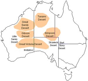 |
| The Deserts of Australia Photo credit: http://www.outback-australia-travel-secrets.com/image-files/australian-deserts.jpg |
 |
| Daintree Rainforest Photo credit: http://www.jennifermarohasy.com//archives/Daintree%20Rainforest.jpg |
Subscribe to:
Posts (Atom)